My title page contents

7.1 earthquake in Honduras

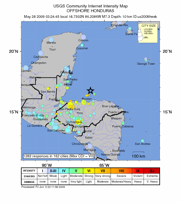
Map of Honduras earthquake on 5/28/09

An Earthquake measuring 7.1 on the richter scale hit 130 Km off the coast of honduras at 3:24 am local time (8:24 UTC) this morning 28/5/09.

  • Thursday, May 28, 2009 at 08:24:45 UTC
  • Thursday, May 28, 2009 at 02:24:45 AM at epicenter
  • Time of Earthquake in other Time Zones
Location 16.733°N, 86.220°W
Depth 10 km (6.2 miles) set by location program
Region OFFSHORE HONDURAS
Distances 125 km (75 miles) NNE of La Ceiba, Honduras
220 km (135 miles) N of Juticalpa, Honduras
310 km (195 miles) NNE of TEGUCIGALPA, Honduras
1185 km (730 miles) SSW of Miami, Florida
Location Uncertainty horizontal +/- 3.6 km (2.2 miles); depth fixed by location program
Parameters NST=377, Nph=377, Dmin=317 km, Rmss=1.1 sec, Gp= 29°,
M-type=centroid moment magnitude (Mw), Version=R
Source
  • USGS NEIC (WDCS-D)

About Adriana Ramos

She holds a Bachelors Degree in International Relations from the Universidad Iberoamericana (Mexico). She has worked in administrative, design, human resources, accounting, and analysis positions for companies as diverse as Avalon Steel Corporation, CSC Continuum-Computer Science Corporation (CSC), Laboratorios Chalber, in the public sector, Mexico’s Foreign Relations Ministry (S.R.E.); Social Media and Marketing Specialist for Non-Profit Organizations as U.S. National Committee of UN Women, East Florida Chapter and Founder Board Member of U.S. National Committee for UN Women Miami Chapter; Founding Board Member Arsht Families Culture for Kids. She is founder of ideas4solutions organization, which has several collaborators from Latin America.