My title page contents

Hurricane #Michael – Florida Take action.

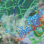
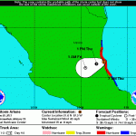
#HurricaneMichael, seen here by #GOESEast, strengthened to a Cat. 4 storm and is now approaching the Florida Panhandle. The @NHC_Atlantic warns that life-threatening storm surge, hurricane-force winds and heavy rainfall are imminent. Latest: http://go.usa.gov/xP9RX NOAA publish his Advisory Number 15 at 4:00 AM CDT Wednesday, Oct 10th. Hurricane Michael is extremely dangerous Category 4 heading toward the Florida Panhandle... Keep reading.   FEMA's text messaging program allows people to look up Emergency Shelter locations via SMS. Text SHELTER and your zip code to 43362 (4FEMA) to find an Emergency Shelter in your area. b\ Standard message and data rates apply. Follow:  @femaregion4 in Twitter. If you need the text version go to: … [Read more...]

Watch Live #Google #Crisis_Response #HurricaneFlorence | Interactive Google Map w/data from NOAA, FEMA, NRL, weather.gov & more

 On Sunday September 16, The official Twitter feed of the N.C. Department of Transportation — NCDOT (@NCDOT) post the following message and image: We know you're worried about property in eastern NC. -Every major route, and those around them, to the coast is flooded. -This isn't over. Water will rise for several days. -Few routes open, help keep them clear for emergency personnel. -Dangerous power lines and trees down pic.twitter.com/qf8cgd4etF — NCDOT (@NCDOT) September 16, 2018 FEMA has Hurricane Florence Rumor control page: https://www.fema.gov/florence-rumors  As 11 a.m. Sunday September 16, the Advisory Number 69 of the National Hurricane Center, said that Tropical Depression Florence continues to produce widespread heavy rains over much of North … [Read more...]

“Arlene” llega a las Costas Mexicanas.

Miami, FL.- Como el mapa del Centro Nacional de Huracanes de los Estados Unidos (NOAA siglas en inglés) lo muestra, las zona en color rojo,  dónde entro la tormenta tropical “Arlene” a las costas mexicanas, aproximadamente a las 7:00 de esta mañana. Se espera posibilidades de ciclón tropical en la zona señalada en el mapa con el punto negro; sin embargo como indica NOAA,  es importante mencionar que los efectos de un ciclón tropical, puede expanderse a ciento de millas de distancia fuera del centro. El área podría ser impactada con vientos fuertes como los de un Huracán, de hasta 74mph, promedio, mencionó NOAA en su reporte. "No se descarta la posibilidad" de que "Arlene" se intensifique, señaló un reporte del Centro Nacional de Prevención de Desastres (Cenapred) … [Read more...]